|
Itineraries
Itinerary I (second part)
by Gustavo Cannizzaro
Church
of Santa Maria dei Minnati Badia
|

Church of S. Maria dei Minniti:
Cimasa
|
The church
has an elegant facade in late Neapolitan Baroque style, on the
granite entrance appears the date 1768 which is the construction
year. Until 1783 the church belonged to the monastery of Santa
Maria di Valverde. Inside there is only the one nave with decorations
in 1700s stucco. Above the entrance is the choir, decorated with
stuccos and with metal grilles covering the openings. On the right
hand wall, under the median archway, there is a small window,
now walled up. It was used for giving the nuns communion. The
door, next to it, was led to the choir area. On the first altar
of the left wall, the painting of SantAnna, the Virgin, San Carlo
and other Saints is the work of a southern Italian painter of
the XVIII century, influenced by Solimena. The main altar is of
interest, built in blended marble and sculpted by local artists
influenced by famous Neapolitan models. The date 1779 is inscribed
in the frontal. Having left the Badia, one finds oneself in via
Vincenzo Niutta, turning right, one reaches the Baglio. Number
40 is the entrance to the old palazzo Hyerace, built at the
end of 1700s following the schemes of XVIII century Neapolitan
palaces with ample entrance in local granite, ashlar-worked with
above it a balcony with coat of arms in wrought iron. The road
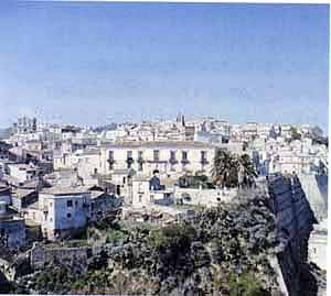
leads into Piano del Baglio, the ancient trading area of the town.
About the ancient importance of this area we refer to Protas
words: The impressive square which is revealed with the name
of Baglio, used to be a kind of external courtyard destined for
weapons, markets, fairs and horse trades, is now much smaller
thanks to landslides, the new road, and new housing apartments.
Baglio or Baglìo is known as a magistrate who judged crimes caused
by the herds of people
this was the place where the weekly market
was held and once a year the great fair, which began on San Nicolas
day and lasted eight days. Today the Baglio is an area at the
service of the town. The recent works on it have redesigned the
space which for years was diminished by the presence of a school
fence. The elongation of via Niutta, now an area for children,
and resting and from where one can look over the valley of the
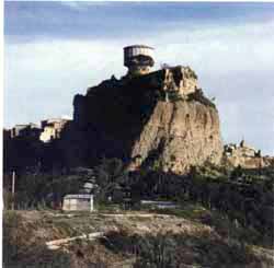
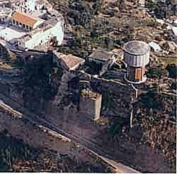
Allaro, give a new look to the Piano Baglio. The ruins of the
castle are a part of the Baglio zone, but they are much more insignificant
than they should be as oldest architectural testimonial of Castelvetere.
The fortress was big as Pacichellis incision remembers. As to
who built it, for whom and why, these are questions which are
nearly impossible to answer. Probably the fortress gave its name
to the town which, over the centuries must have been the dwelling
place of the various feudal lords. The most antique scripture
mentioning the existence of the fortress belongs to 1323, when
Leone de Regio, a military man, was its owner (le
pergamene angioine dellarchivio Carafa di roccella edited by
V. Naymo).
|
|
From
a description of the secon half of the XVI century (also edited
by Naymo), the dimensions are recorded as covering so vast an
area that it included four apartments able to hold four princes
as guests. It is known that the fortress was home to the Carafa
della Spina family Marquises of Castelvetere between 1479 and
1673. From the end of the 1600s until 1783, year of the earthquake,
it was home to trusted friends of the Carafa family, who ruled
under the title of Vice-marquis. The documents also reveal that
many alterations were made to it because of new military techniques
and earthquake damage which repeatedly destroyed the buildings
in Castelvetere. After the earthquake of 1783 which destroyed
most of the castle, there began a period of total negligence.
In 1842 all the ruins were catalogued by Ilariantonio Taranto,
who also installed a spinning frame and a brick bridge which substituted
the draw-bridge. Subsequently the castle, in passing through various
new owners, was firstly used as a garden, then, new housing was
made in it. Finally, in the 1960s, part of the land was expropriated
by the Prefettura di Reggio Calabria by request of the Cassa per
il Mezzogiorno, with the extremely sad intention of building a
massive cistern for supplying water to the town, on it.All that
remains today of the ancient structure is the entrance gateway,
two ramps of the great staircase and fragments of the perimeter
curtain along with the square donjon on the northern side and
the turret on the south side. Returning to the lower part of the
Baglio, through the final part of via Vincenzo Niutta one reaches
Via del Rosario which represents one of the most characteristic
aspects of Caulonia: i vinedi. These lanes which end in small
clearings and which wind among low and multi-floored houses, which
all have balconies and are connected to eachother by archways
and steep stone steps, lead to the church of the SS. Rosario,
home of the homonymous confraternity.
The SS.
Rosario church

Church of SS. Rosario |
Originally,
the church belonged to the convent of the Dominican Fathers, founded
in 1540 under the protection of Livia Spinelli, wife of Geronimo
Carafa. It was damaged in the earthquake of 1783 and was reconstructed
in 1788. Later, during the French occupation, the convent was
suppressed and the arch-confraternity which used to have its home
in the convent, inherited the church. It has only one nave and
it underwent many changes during the embellishing work which ended
in 1895. This date is inscribed in the pavement under the entrance
doorway. The lacunar ceiling, the gold ceiling roses and the apses
stuccos all belong to that period. The walnut pulpit is interesting,
made by Reggian artisans between the end of the XIX century and
the beginning of the XX century. There are two paintings depicting
the Annunciation scene and the Miracle of San domenico in Soriano,
by a local artist, Vincenzo Raschellà, in 1898; hangings from
the XIX century; a monstrance by the Neapolitan silversmith G.
Mercurio; some Neapolitan shepherds from 1700s and 1800s and a
white marble tombstone on which a lying female figure wearing
1500s style clothing, is sculpted. The tombstone, of southern
Italian manufacture of the XVI-XVII centuries, is traditionally
known as the princesss tomb, however it remains unclear which
princess she was. Prota seems to think it could be the sepulchral
slab of Giulia Tagliavia dAragona, wife of Fabrizio Carafa, who
died on the 25th of November 1621. However, an inscription
on the back of the slab suggests that the tombstone belongs to
Livia Spinelli, whom we know was closely tied to the Dominican
church. This church, however, was close to the hearts of all members
of the house of Carafa. Carlo Maria Carafa and Branciforte, prince
of Butera and Roccella, stated in his testament (part of which
was quoted by F. Racco in his Feudal Codification of 1600s Calabria),
that if he was to die in Calabria, his body was to be buried in
the church of SS.ma Annunciata dei P.P. Domenicani, as the church
del Rosario was then called, in Castelvetere.The prince died in
Sicily on the 1st of June 1695 in Mazzarino and was
buried, again on his request, in the church of Santa Maria di
Gesù. Leaving the church and
descending the homonymous street, one joins via Vincenzo Niutta.

Via Vincenzo Niutta |
This road, built in the
second half of the XIX century and paved during the first years
of the XX century, was created by demolishing the Santa Barbara,
the San Felice and the Santa Maria alleys. This is a clear example
of the gutting style politics of urban planning adopted by Umbertino
Italy (which included Naples, Rome and Florence). The road divides
the high area of the town from the low area and it snakes from
Via Roma to the Baglio. Walking up the road again, one reaches
Piazza Mese; on the left side, just before reaching the square,
one can see the XIX century facade of the Hyerace palace.
|